Monday, February 10, 2025

Whipple Hill and Arlington Great Meadows winter hike - February 5, 2025

 HIKE REPORT 

Wednesday, 5 February 2025, Whipple Hill and Arlington Great Meadows winter hike
Hike Leader:  Tom Allen

5 miles, 10:00 am start from Lexington, MA


Hikers (9):  Tom, Barbara Jacobs, Jack Mroczkowski, Janet Miller, Marc Baskin, Marie Keutmann, Marlene Heroux, Ted Nyder, and William Feiring.


Nine of us met at the bright, but chilly, parking area in Lexington with traction spikes at the ready.  I advised that folks wouldn't need them until further along, as we had some paved walking to do.  However, the combination of snow, thaw, and freeze in the prior couple of days made all path walking pretty much just ice.


We started down a small hidden path to the Arlington Reservoir (aka "the Rez"), proceeding very gingerly.  Upon reaching the Rez path we encountered a very conveniently located bench where we all sat and installed our various traction aids.


Proceeding around the reservoir and along a couple of short street blocks, we arrived at the Whipple Hill trailhead.  One of our participants decided that her spikes were not up to the icy conditions and opted to return to the start, taking a street route that could give her a good walk without footing challenges.  The rest of us proceeded along the trail despite the dodgy surface conditions.  It was quiet and serene with only a couple of dog walkers encountered.  Quiet except for the crunching of spikes on ice.  

At one point the leader lost the intended track and we took a steeper. but shorter, route to the summit of Whipple Hill.  We could see Mt. Wachusett and some unidentified water towers in the distance.


Descending via a different trail, we left the Whipple Hill Conservation Area and proceeded along streets to the entrance to Arlington Great Meadows to enjoy more icy trails, but with less climbing.  The Great Meadows trails took us to the Minuteman Bikeway, not far from our starting point.  The bikeway was plowed, so with the aid of another conveniently placed bench, we were finally able to shed our traction devices.


Eight hikers convened for soup, salad and sandwiches at the Great Harvest Bread Company.


Report by Tom Allen.


Monday, February 3, 2025

Wellesley to Newton Upper Falls winter hike - January 29, 2025

 HIKE REPORT


Wednesday, 29 January 2025, Wellesley to Newton Upper Falls winter hike
Hike Leader:  Susan Sabin

6 miles, 10:30 am start from Wellesley, MA


Hikers (12):  Susan, Aiko Pinkoski, Ann Northup, Frank Calabrese, Jeffrey Whalen, Jim Whinfield, Lisa O’Connor, Mike Hanauer, Molly Schaeffer, Susan Broome, Todd Palmer, and first-timer Debra Mello.


Seventeen WWs registered for this walk, but only twelve met at the start.  Two cancelled and one had a GPS that led them to Oak Street, not Oakland, leaving us with two phantom registrees.  The leader hopes that the other two are not still looking for the group.


As leader, I regret that I didn’t take the time for welcomes, because many of these folks were new or newish to the walking groups.  My excuse was the weather forecast which called for mild temps and sun in the morning, followed by winds of up to 40 mph after 12:00 pm, along with showers.  The morning forecasts were accurate, the ones for the afternoon were not and I needn’t have rushed.  It remained mild and completely benign and turned out to be a great day for a walk.


Most of the walk followed the Sudbury Aqueduct trail to Newton Upper Falls which, because of the water power provided by the Charles, was a major industrial site in colonial times.  Although signs of early industry can still be found in the village, the twentieth century saw a change in character, when Hemlock Gorge was developed as a recreational area with meandering trails, an amphitheater and a large dance pavilion.  We walked on the paths laid out in the area, but neither the dance hall nor the amusement park features remain visible.

  
But we did walk on a tiny length of Rte 9, an early turnpike road which, having existed as a dirt road in colonial days, has since been paved, widened, and become a public way.  Everyone stopped halfway for lunch after which we retraced our route, this time heading back west on the famous Echo Bridge, over the aqueduct trails, and eventually to our cars - a six mile route in all.


In March, my hike will start in the same location, then head in the opposite direction, to the industrial area which grew up around Newton Lower Falls.  This hike will cross Rte 9 and be mainly along wooded trails within hearing distance of Rte 128 (I-95), now an undeveloped area!!  How times change!


Report by Susan Sabin.

Monday, January 27, 2025

XC Skiing at Great Brook Ski Touring Center - January 22, 2025

 XC SKI REPORT


Wednesday, 22 January 2025, XC Skiing at Great Brook Ski Touring Center
Leaders:  Margie & Tony Lee
Skiers (6):  Margie, Tony, Barbara Martin, Betty Salzberg, Susan Broome, and Susan Sabin.

We purchased tickets and met by the pot-bellied stove in the barn.  The day was clear and bright with a starting temperature of 13, but no wind.  Tuesday's Great Brook xc ski report was that conditions were "generally good", but we soon discovered a lot of bare spots, with exposed rocks and roots.  There were a couple of hard falls, but, fortunately, no real injuries.  [One person quit after an initial assessment of the trails.] 

We made steady, but slow, progress, especially compared to the Harvard xc ski team that breezed right past us.  There were a few areas of powder snow reminiscent of Monday's conditions, but we all agreed that Great Brook was not great today.  Thanks to the participants for their patience and perseverance.  Most of us enjoyed being out on this beautiful winter day.

Four of us went for apres-ski lunch at Fern's Country Store in Carlisle.


Report by Margie Lee.


Monday, January 20, 2025

Wayland - Hike the Eskers - January15, 2025

 HIKE REPORT


Wednesday, 15 January 2025, Wayland - Hike the Eskers
Hike Leader:  Betty Salzberg
4 miles, 10:00 am start from Wayland, MA


Hikers (11): Betty, Barry Kaditz, Frank Calabrese, Jim Whinfield, Jonathan Kannair, Marc Baskin, Margie Lee, Marie Keutmann, Richard Vignoni, Susan Broome, and William Feiring.

We started our hike at the access road near 30 Grove Street in Wayland which leads to the hosta farm and then along the Sudbury River.  The access road intersects Old Oxbow Road which is a town road that is not
paved, and continues along the river until it meets Oxbow Road which
is paved.

From Oxbow Road we went into Trout Brook Conservation area and walked
along the esker, looking down at the marshes along Trout Brook and a
few large kettleholes.  Then we crossed Sherman’s Bridge Road and went
along Alpine Road to Alpine Field and the entrance to Castle Hill
Conservation area.  After crossing Hazel Brook which flows out of
Schoolhouse Pond at a large beaver dam, we continued walking on more
eskers looking down at the pond.  We then retraced our steps, making a
detour along the old horse track used by the Minuteman to get to
Concord and the North Bridge in the start of the Revolutionary War.
Back at Trout Brook, the leader made a wrong turn and we got down into
the marshes, but not where there was any trail.  Climbing back out, we
made it back to our cars and about eight of us had lunch at Verrill Farm
in Concord.

Report by Betty Salzberg.


Monday, January 13, 2025

Adams & Wright Woods winter hike - January 8 , 2025

 HIKE REPORT


Wednesday, 8 January 2025, Adams & Wright Woods winter hike

Hike Leaders:  Marie Keutmann & Barbara Jacobs

 ~5.5 miles, 10:00 am start from Lincoln, MA


Hikers(16):  Marie and Barbara, Annemarie Altman, Barbara Martin, Betty Salzberg, Clyde Kessel, Greg Stathis, Jack Mroczkowski, Janet Miller, Jim Whinfield, John Trotter, Marc Baskin, Phyllis Evan, Steve Hoffenberg, Ted Nyder, and first-timer Rena Sokolow.


Sixteen hikers met at Red Rail Farm in Lincoln in sunny, but cold and blustery, conditions.   The hikers set out through the woods along the many ups and downs of the kettle holes left behind by glacial activity.  We walked around a bicycle race track, or velodrome, that is the sole visible remains of a mid to late 1800’s fairground which people reached by steam locomotive on the Fitchburg line.  At the velodrome, I gave a brief talk about the history of the fairgrounds (see link below) before we walked around the perimeter of the track.  We climbed a steep trail to the top of Fairhaven Hill, where Jack gave a brief talk about the large estate with Buddha statues and an ice rink at the summit.  We then worked our way over to a route along the Sudbury River with great views of the river and Fairhaven Bay.  From there it was back into the woods and back to our cars.  The crisp temps and bright skies made for a great day of hiking.


Thanks to Barbara Jacobs for helping me navigate the route and to Betty Salzberg for sweeping.


Approximately twelve people had post-ride lunch in the greenhouse at Verrill Farm.


Report by Marie Keutmann.


Additional Information on Racetrack and Fairgrounds


The bicycle race track was part of the fairgrounds from the late 1800's.  The track is about 500 ft in circumference and has a pronounced bank on one end.  In its heyday, the fairground included a dance hall, a restaurant, a baseball field, a race track, and amusements.  On weekends, people flocked by the thousands to “Lake Walden” on the Fitchburg train line to go boating, swimming, and to use the fairgrounds.  The fairgrounds were built by the owners of the railroad to encourage ridership.  There were several fires over the years, likely due to sparks from the steam locomotives, so in the early 1900's it ceased to exist.  Today, the only visible remains are the race track and cleared ground between the trees.


Click on the link below and view Exhibition Images 5 to 8 which show the entrance gate to “Walden,” the picnic grounds and the amusement park buildings:


Online Exhibition of Walden Pond images

Information on Wright woods where we hiked


Monday, December 23, 2024

Two Famous Swing-Era Ballrooms, plus lots more! - December 18, 2024

 HIKE REPORT


Wednesday, 18 December 2024,, Two Famous Swing-Era Ballrooms, plus lots more!

Hike Leaders:  Zach Woods & Judy Perrin

5.8 miles (~4 hours including lunch)10:00 am start from Auburndale, MA


Hikers (21):  Judy, Zach, Aiko Pinkoski, Barbara Jacobs, David Goldberg, David Wean, Gerry Sheetoo, Jim Whinfield, Joanne Samuels, Kristina Leclaire, Marc Webb, Marie Keutmann, Mike Hanauer, Patrick Ward, Phyllis Evan, Renee Rees, Steven Venizelos, Susan Amsel, Susan Sabin, Ted Nyder, and Todd Palmer.


The weather was almost too warm and sunny, but our large group enjoyed exploring along the Charles River starting in Auburndale, moving east to Waltham, and then crossing the river to head back west to Weston and, eventually, east into Auburndale.  Along with enjoying the scenery and chatting along the way, we stopped to talk about recreation, industry, and history.


At about the halfway point, lunch was enjoyed at the South Street Cafe in Waltham.  There were some good laughs along the way as we passed by the Norumbega Tower that was built in an effort to reinforce the inaccurate claim that Vikings had settled along the Charles River in the early 1000s, and as we passed the Boston Marriott which is no longer owned by Marriott and is located in Auburndale, not Boston.


There was also a lot of interest in the life and significant first in history achievements of early woman architect, Ida Annah Ryan.  We even discovered, as we walked by different locations, that folks among our number were famously connected to those locations as follows:  one plays Pickleball at The Cove; one attended a college visible along the way; one grew up in a neighborhood we passed; another’s childhood home was visible across the Charles River from our route; one member of the group had attended their high school prom in the Totem Pole Ballroom in Norumbega Park (before it burned down)!


Report by Zach Woods.


Photos:

     The group admiring the Norumbega Tower and the view from the top of the Tower (photos by David Wean).

     View of the Waltham Watch Factory across the Charles River from the Mt. Feake Cemetery (photo by Kristina Leclaire).


Monday, December 9, 2024

Hike from Twin Pond to Pigeon Hill Folly Ruin and Back - December 4. 2024

 HIKE REPORT


Wednesday, 4 December 2024, Hike from Twin Pond to Pigeon Hill Folly Ruin and Back

Hike Leaders:  Zach Woods & Judy Perrin

5.5 miles (~2.75 hours), 10:00 am start from Lincoln, MA


Hikers (15) Judy, Zach, Aiko Pinkoski, Annemarie Altman, Betsy Kimball, Betty Salzberg, David Goldberg, David Wean, Jim Whinfield, Kristina Leclaire, Marie Keutmann, Melissa Norton, Renee Rees, Steven Venizelos, and Susan Sabin.

Present at lunch:  Frank Aronson.


Cold but sunny weather made for a great hike with little to no wind and temperatures starting just below freezing and finishing up at nearly forty degrees.  Everyone had a great time on the walk, talking and discussing several historical sites (Garfield cellar hole, Pigeon Hill Folly, and the former site of a colonial era rope walk where hemp fibers were worked into lengths of rope) and some natural features, including a hogback ridge formed by a glacier and Pigeon Hill which was named for all the countless, now extinct, passenger pigeons that used to flock there.  We also learned about several of the Modernist houses viewable from the trail.


Six folks enjoyed lunch at Revolution Craft Food Hall in Lexington after the hike, including Frank Aronson who was not able to join us for the hike.


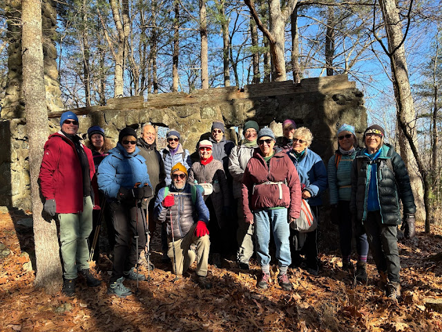
The attached group photo was taken at the Pigeon Hill Folly ruin.


Report by Zach Woods.